Xizang
Panorama of Xizang Autonomous Region
The Xizang Autonomous Region, referred to as "Tibet" for short, is located in the southwest border of China and the southwest of the Qinghai Tibet Plateau. It is the region with the highest altitude in the world, known as the "roof of the world". The total area of the district is 1.2028 million square kilometers, accounting for about 1/8 of the total area of the country. It has 6 prefecture level cities and 1 region under its jurisdiction, with a permanent population of 3.64 million people (2022 data). In 2022, the gross domestic product of the entire region reached 213.2 billion yuan, and the economic growth rate has been among the top in the country for many consecutive years. It is an important ecological security barrier and a unique cultural tourism destination in China.
Xizang now governs six prefecture level cities, namely Lhasa (the capital), Shigatse, Changdu, Linzhi, Shannan and Naqu, and Ali region. As the main birthplace of Tibetan culture in China, Xizang is known as the "Pure Land on Earth" and the "Third Pole of the Earth". It is also an important biological gene pool and water tower in Asia.
2Īó Geographical features
1. Location characteristics
Xizang is located between 26 ĪŃ 50 '-36 ĪŃ 53' north latitude and 78 ĪŃ 25 '-99 ĪŃ 06' east longitude. It borders Xinjiang in the north, Sichuan in the east, Qinghai in the northeast, Yunnan in the southeast, Myanmar, India, Bhutan, Nepal and other countries in the south and west. The border line is about 4000 kilometers long. It is an important gateway to China's southwest border.
2. Terrain and landforms
The average altitude in the entire region is over 4000 meters:
Northern region: Northern Tibetan Plateau (with an average elevation of 4500 meters)
South: South Tibet Valley (the Yarlung Zangbo River basin)
East: Hengduan Mountains
West: the Himalayas (Mount Everest 8848.86 meters)
Typical landforms: glaciers, lakes, canyons
3. Water system distribution
The Yarlung Zangbo River: Mother River of Xizang
Nujiang River, Lancang River, Jinsha River: Three Parallel Rivers
Lakes: Namtso, Selincuo, Yangzhuoyongcuo
Glacier: Puruogangri Glacier, etc
4. Climate characteristics
Belonging to the plateau cold zone and temperate climate:
Annual average temperature: -2.8 to 11.9 Īµ
Annual precipitation: 100-500 millimeters
Significant features: thin air, abundant sunshine, large temperature difference between day and night
3Īó Historical context
1. Origin of Civilization
Neolithic Age: Karuo Culture Site (5000 years ago)
Zhangxiong Civilization: Xizang's Early Civilization (4th Century BC)
Tubo Dynasty: Songtsen Gampo Unifies Xizang (7th Century)
2. Organizational history
Yuan Dynasty: Formally incorporated into the central government's territory
Ming Dynasty: Establishment of the Wusi Zangdusi
Qing Dynasty: Establishment of the Resident Minister System in Tibet
1965: Xizang Autonomous Region was established
3. Important historical periods
Tang Fan's marriage alliance: Princess Wencheng enters Tibet
Development of Tibetan Buddhism: Formation of Gelugpa and other sects
Peaceful Liberation: 1951
Democratic Reform: 1959
Reform and Opening up: A New Era of Modernization Construction
4Īó Cultural Essence
1. Tibetan cultural characteristics
Tibetan Buddhist Culture: Temple Architecture, Thangka Art
Nomadic culture: yak culture, tent living
Agricultural culture: Highland barley cultivation, terraced farming
Festive Culture: Tibetan New Year, Shoten Festival
2. Intangible Cultural Heritage
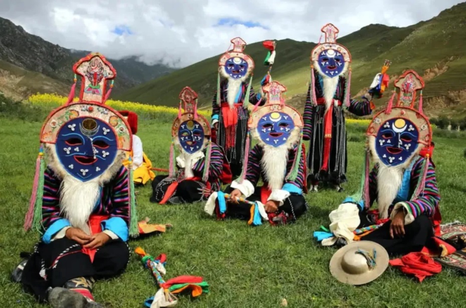
Folk art: Thangka, Tibetan carpets, Tibetan knives
Traditional skills: making Tibetan incense, processing Tibetan medicine
Folk culture: mountain turning, kowtowing
3. Language and Writing
Tibetan: Three major dialect regions
Tibetan: Created during the Songtsen Gampo period
Other minority languages: Menba language, Luoba language
5Īó Tourist destinations
1. World Heritage Sites
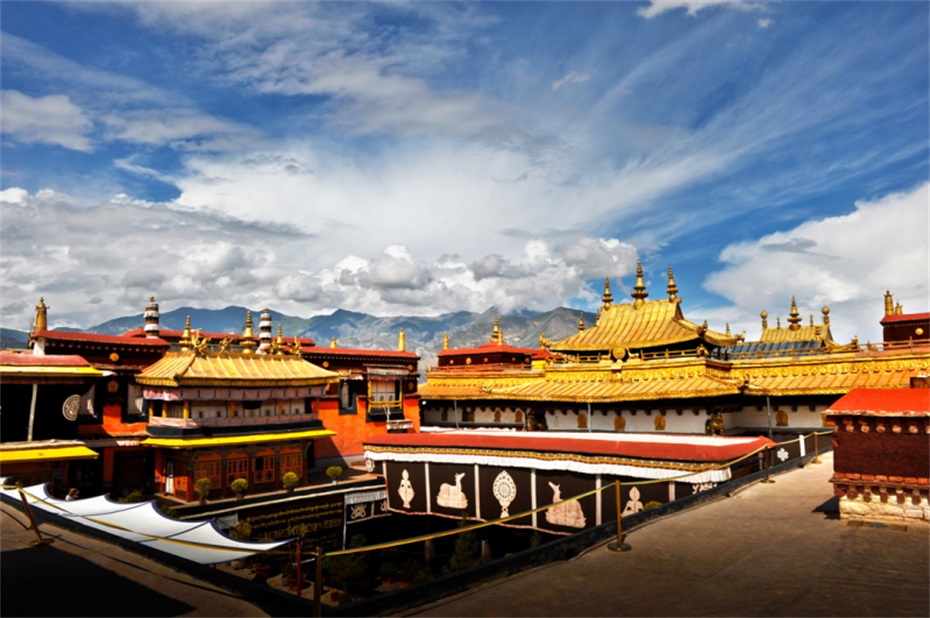
Jokhang Temple
Norbulingka
2. 5A level scenic spot
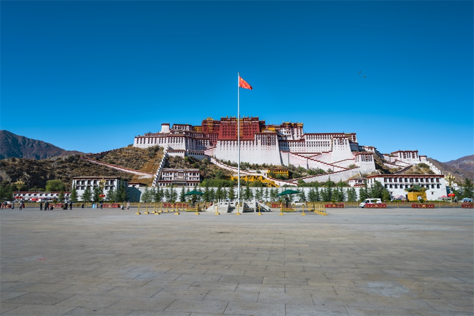
Potala Palace Scenic Area
Jokhang Temple Scenic Area
Zhashilunbu Temple Scenic Area
Basongcuo Scenic Area
3. Featured tourism
Holy Lake Pilgrimage Tour: Namtso, Yangzhuoyongcuo
Snow Mountain Adventure Tour: Mount Everest Base Camp
Tibetan Cultural Experience Tour: Barkhor Street, Tibetan Home Visits
Ecological sightseeing tour: Yarlung Zangbo Grand Canyon
6Īó Food map
1. Characteristics of Tibetan cuisine
Tsamba: barley fried noodles
Butter tea: a daily beverage
Yak meat: Dried yak meat
Tibetan noodles: Plateau specialty noodles
2. Featured snacks
sweet tea
Cangbaozi
quark
Ginseng fruit Rice
Yak yogurt
3. Specialty drinks

saffron
Cordyceps sinensis
butter
7Īó Development Status
1. Industrial system
Featured Agriculture and Animal Husbandry: Highland Barley and Yak Industry
Green industry: natural drinking water, Tibetan medicine
Cultural Tourism Industry: Comprehensive Tourism Demonstration Zone
Clean energy: solar energy, geothermal development
2. Transportation network
Airline: Lhasa Gongga International Airport
Railways: Qinghai Tibet Railway, Lalin Railway
Highways: Sichuan Tibet Highway, Xinjiang Tibet Highway
Rural roads: 100% connectivity rate in established villages
3. Ecological protection
National ecological security barrier
47 nature reserves
ecological compensation mechanism
Prohibited development areas account for 34% of the entire district
From snow mountain holy lake to temple prayer flags, from yak tents to modern new cities, this "roof of the world" is writing a magnificent chapter of Xizang's development in the new era with the "old Xizang spirit" and the "two way spirit". There is both the purity of "the closest to heaven" and the vitality of "a happy new Xizang", which is becoming an important window to show the successful practice of China's regional ethnic autonomy system.
simliy